
फाइल:Amazonrivermap.png
इ पूर्वावलोकन कय आकार: ६०० × ६०० पिक्सेल । अउर resolutions: २४० × २४० पिक्सेल | ४८० × ४८० पिक्सेल | १,००० × १,००० पिक्सेल।
मूल फ़ाइल (१,००० × १,००० पिक्सेल, फाइल आकार: ५५१ केबी, MIME प्रकार: image/png)

|
File:Amazonrivermap.svg is a vector version of this file. It should be used in place of this PNG file when not inferior.
File:Amazonrivermap.png → File:Amazonrivermap.svg
For more information, see Help:SVG. |
 |
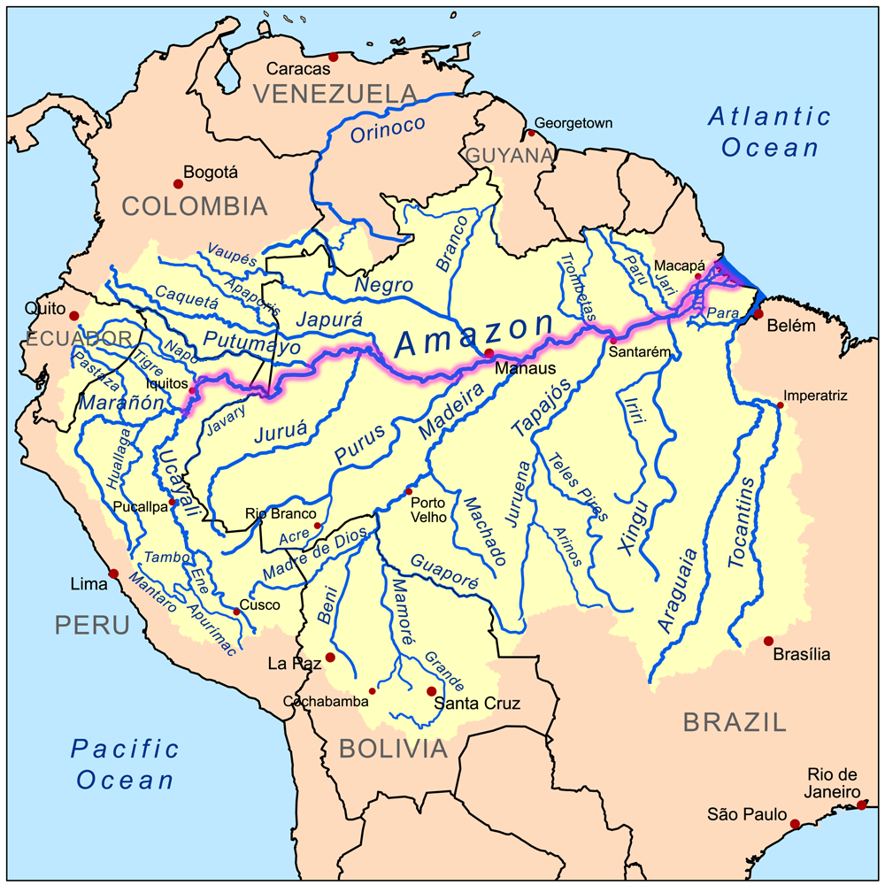
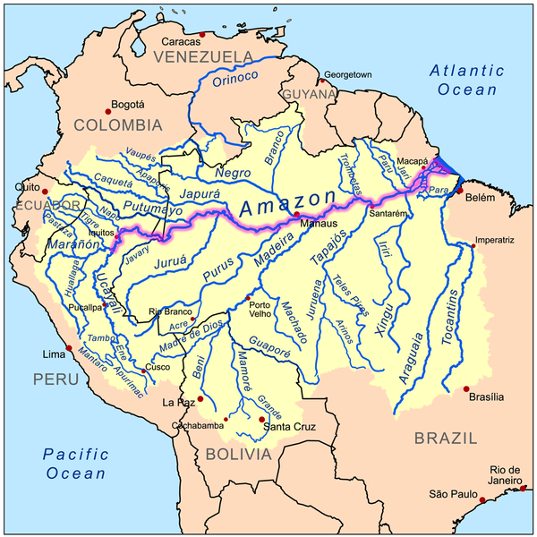
| जानकारी | This is a map of the Amazon River drainage basin with the Amazon River highlighted. |
| दिनांक | |
| स्रोत | Own work using Digital Chart of the World and GTOPO data. |
| लेखक | Kmusser |
मैं, इस कार्य का/की कॉपीराइट धारक, इसे निम्न लाइसेंस के अंतर्गत प्रकाशित करता/करती हूँ:
यह फ़ाइल लाइसेंस्ड हैं इस अंतर्गत क्रिएटिव कॉमन्स एट्रीब्यूशन-शेयर एलाइक ३.० अनपोर्टेड़ लाईसेंस ।
- तुम मुक्त हो:
- साझा करें – रचना को कॉपी, वितरित और संचारित करने के लिए
- रीमिक्स करने के लिए – काम अनुकूलित करने के लिए
- निम्नलिखित कारणों के अंतर्गत:
- एट्रीब्यूसन – आपको रचना का श्रेय लाइसेंसकर्ता अथवा लेखक के बताये गए माध्यम से देना होगा (परन्तु इस प्रकार नहीं की उससे लगे कि वे आपको अथवा आपके द्वारा रचना के प्रयोग का समर्थन करते हैं)।
- शेयर अलाईक – यदि आप सामग्री का रीमिक्स, रूपांतरण, या निर्माण करत हैं, तौ आपका अपने योगदान का मूल के रूप मा [1] या संगत लाइसेंस के तहत वितरित करय का परे।
फाइल कय इतिहास
मिति/समय मे क्लिक कइकै फाइल उ समय कैसन बिलगात रहा देखा जाय
| तारीख/समय | अंगूठाकार प्रारूप | आकार | सदस्य | टिप्पणी | |
|---|---|---|---|---|---|
| अबहिनै कय | ००:३२, २० दिसम्बर २०२२ | | १,००० × १,००० (५५१ केबी) | Italyoz484 | |
| २२:३४, १ सितम्बर २०२२ |  | १,००० × १,००० (५८३ केबी) | Wolf170278 | Tocantins doesn't belong to the amazon river basin | |
| २२:४५, ८ सितम्बर २००८ |  | १,००० × १,००० (५५१ केबी) | Kmusser | {{Information |Description=This is a map of the Amazon River drainage basin with the Amazon River highlighted. |Source=Own work using http://www.maproom.psu.edu/dcw/ Digital Chart of the World and [[http://edc.usgs.gov/products/el |
फ़ाइल कय उपयोग
इ फाइल से कवनो पन्ना नाइ जोडान है ।
वैश्विक फाइल प्रयोग
अउर विकि जवन इ फाइल कय प्रयोग करत हँय:
- da.wikipedia.org पर उपयोग
- de.wikipedia.org पर उपयोग
- de.wikinews.org पर उपयोग
- en.wikipedia.org पर उपयोग
- he.wikipedia.org पर उपयोग
- ko.wikipedia.org पर उपयोग
- lez.wikipedia.org पर उपयोग
- nn.wikipedia.org पर उपयोग
- no.wikipedia.org पर उपयोग